Chena River Watershed
“The word "watershed" is sometimes used interchangeably with drainage basin or catchment. Ridges and hills that separate two watersheds are called the drainage divide. The watershed consists of surface water--lakes, streams, reservoirs, and wetlands--and all the underlying groundwater.”
— USGS.GOV
The Chena River
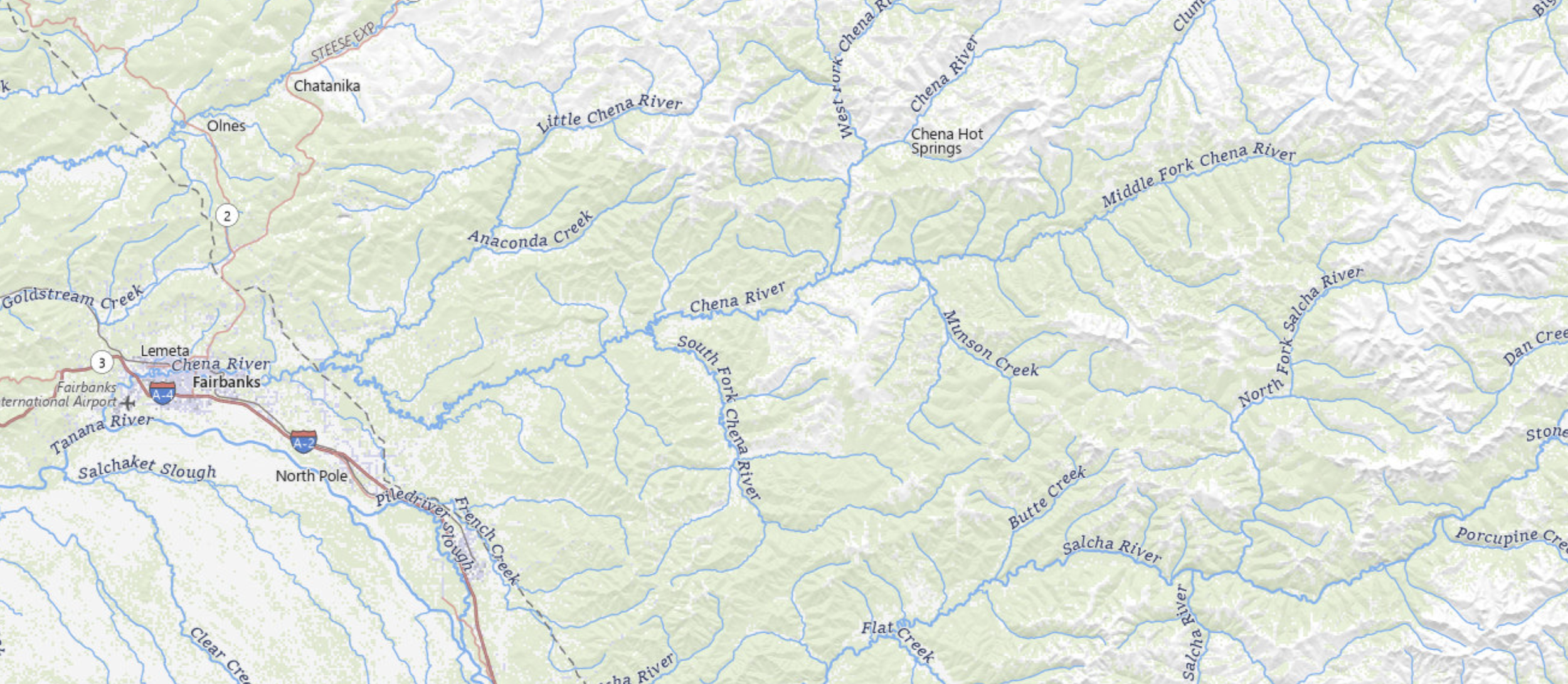
The Chena River (Tanana Athabascan: Ch'eno' meaning "river of wildlife") is a 100-mile (160 km) tributary of the Tanana River in the Interior region of Alaska. It flows westward from the White Mountains to the Tanana River near Fairbanks. The Tanana empties into the 2,300-mile (3,700 km) long Yukon River.
Named tributaries of the Chena River include the North Fork, South Fork, West Fork, Middle (East) Fork, and the Little Chena River. The Chena River State Recreation Area surrounds much of the upper half of the main stem. The Chena River is a popular recreational area for fishing and boating. It is also traveled by snowmachines and mushers (sled dogs) during the winter months.
The Chena River Lakes Flood Control Project dam is about 40 miles (64 km) up the Chena River from Fairbanks. In 1967, Fairbanks flooded, inundating much of the city, and a dam was constructed in response. When closed, the dam impounds water and, when the inflow is high enough, diverts it about 8 miles (13 km) to the Tanana River near North Pole city, upstream of Fairbanks and the natural mouth of the Chena.
Fish
The Chena River supports populations of many fish species, including Arctic grayling, burbot, chum salmon, humpback whitefish, king salmon, least cisco, longnose suckers, northern pike, round whitefish, and sheefish. Easily accessible from Fairbanks, the Chena is interior Alaska's most popular sport-fishing river.
Overfishing for grayling reduced their number in the Chena to "dangerous levels" by the mid-1980s. In the 21st century, sport fishing for grayling, which grows to 18 inches (46 cm) in the upper river, is limited to catch-and-release.
Recreation
Access to the river from Chena Hot Springs Road, the Chena River Recreation Area, four bridges, and elsewhere makes various float trips possible. Most of the river is rated Class I (easy) on the International Scale of River Difficulty; however, the upper reaches along the North Fork near Chena Hot Springs are "extremely swift" with few safe eddies and are rated Class II (medium). High water increases these difficulty ratings.
Dangers on the North Fork include a much narrower channel than the main stem, possible logjams, overhanging vegetation, and shallows, which may require a portage. The dangers below include possible overhangs, logjams, and channel braiding. In the early season (June), boaters may encounter ice jams anywhere along the river.
Threats to Chena’s Watershed
The Chena River and its watershed are relatively pristine but are still affected in several ways. As the river flows through greater Fairbanks, it picks up pollutants like motor oil from parking lots, plastic grocery bags, pesticides, fertilizers, detergents, and sediments. If left untreated, runoff from rain and snowmelt directly into waterways carries these pollutants. These contaminants can infiltrate groundwater, accumulate in streams and rivers, and eventually flow down the watershed into the ocean.
Protecting a Watershed
Everyone impacts Alaska’s fish and wildlife resources and the habitats they depend on, but not everyone understands their role in maintaining a sustainable future for these resources. Here are a few things you can do to help keep Chena’s watershed healthy and vibrant:
1. Reduce Pollution at the Source
- Use environmentally friendly products and dispose of hazardous materials properly.
- Implement best practices in agriculture, such as using organic fertilizers and pesticides and reducing soil erosion through crop rotation and cover cropping.
- Maintain vehicles to prevent oil and other fluids from leaking.
2. Manage Runoff
- Install rain gardens, permeable pavements, and green roofs to reduce and filter stormwater runoff.
- Create buffer zones with native vegetation along waterways to filter pollutants before they reach the water.
3. Restore and Preserve Natural Habitats
- Protect and restore wetlands, which act as natural filters for pollutants.
- Conserve forests and other natural areas that provide essential watershed functions.
4. Promote Sustainable Land Use Practices
- Implement zoning and land use planning that minimizes development in sensitive watershed areas.
- Encourage the use of green infrastructure in urban planning.
5. Educate and Engage the Community
- Raise awareness about the importance of watershed protection and ways individuals can help.
- Involve local communities in monitoring and restoration projects.
6. Regulate and Enforce
- Establish and enforce regulations that limit pollution and protect water quality.
- Monitor water quality regularly to ensure compliance and identify sources of pollution.
By combining these strategies, communities can effectively protect their watersheds and ensure clean water for future generations.